Emory University
Candler School of Theology
Pitts Theology Library
Pitts Digital Collections
x
Home
Collections
Exhibitions
Search
About
Emory University
Candler School of Theology
Pitts Library
Pitts Digital Collections
Search
Search
Advanced
Collection
Abba Baptist (Irwin County, Ga.)
Abbeville Methodist (Wilcox County, Ga.)
Academy Baptist (Jackson County, Ga.)
Acworth Presbyterian Church (Cobb County County, Ga.)
Adel Presbyterian Church (Cook County, Ga.)
Adgateville Baptist (Jasper County, Ga.)
African Missionary Postcard Collection
Akin Methodist (Wayne County, Ga.)
Albert, of Brandenburg, Archbishop and Elector of Mainz, Cardinal letter
Albertus Dei et Apostolice Sedis gratia Maguntinen[sis] [sic] et Magdeburgen[sis] Archiepiscop[us] ac Halberstaten[sis] ecclesiar[m] Administrator, Germanie Primas ... Indulgence
Albrecht Dürer, Woodcut collection
Alexander Memorial Presbyterian Church (Dekalb County, Ga.)
Allenhurst Presbyterian Church (Liberty County, Ga.)
Alpine Presbyterian (Chattooga County, Ga.)
Altama Presbyterian Church (Glynn County, Ga.)
Ambrose Christian (Coffee County, Ga.)
American Academy of Religion Annual Meeting programs
American Academy of Religion records
Andrews Chapel Methodist (Coweta County, Ga.)
Andrews Chapel Methodist (Whitfield County, Ga.)
Antioch Baptist (Taliaferro County, Ga.)
Antioch Baptist (Washington County, Ga.)
Antioch Christian (Oconee County, Ga.)
Antioch Methodist (Clinch County, Ga.)
Antioch Methodist (Colquitt County, Ga.)
Antioch Primitive Baptist (Stewart County, Ga.)
Apple Valley Baptist (Jackson County, Ga.)
Arcade Presbyterian Church (Jackson County, Ga.)
Atcooga Presbyterian Church (Whitfield County, Ga.)
Attapulgus Presbyterian Church (Decatur County, Ga.)
Austell Presbyterian Church (Cobb County, Ga.)
Axson Methodist (Atkinson County, Ga.)
Baptist Rest Primitive Baptist (Emanuel County, Ga.)
Bark Camp Baptist (Burke County, Ga.)
Barnesville Presbyterian Church (Lamar County, Ga.)
Barnett Methodist (Warren County, Ga.)
Barnett Presbyterian Church (Warren County, Ga.)
Barnwell Chapel (Floyd County, Ga.)
Bath Presbyterian (Richmond County, Ga.)
Bay Springs Methodist (Washington County, Ga.)
Beaverdam Baptist (Wilkes County, Ga.)
Beersheba Presbyterian Church (Chattooga County, Ga.)
Benevolence Baptist (Randolph County, Ga.)
Benevolence Methodist (Crawford County, Ga.)
Bengt Runo Hoffman, Youngsters from the German highways
Ben Hill Presbyterian Church (Fulton County, Ga.)
Berlin United Methodist Church (Hephzibah, Ga.)
Beth-Salem Presbyterian (Oglethorpe County, Ga.)
Bethany Baptist (Harris County, Ga.)
Bethany Congregational Church (Thomas County, Ga.)
Bethany Presbyterian (Greene County, Ga.)
Bethany Presbyterian Church (Newton County, Ga.)
Bethel Baptist (Heard County, Ga.)
Bethel Baptist Church (Wilkinson County, Ga.)
Bethel Brick Methodist (Screven County, Ga.)
Bethel Methodist (Charlton County, Ga.)
Bethel Methodist (Coweta County, Ga.)
Bethel Methodist (Troup County, Ga.)
Bethel Methodist (Wilkes County, Ga.)
Bethel Presbyterian (Chattooga County, Ga.)
Bethel Primitive Baptist (Brooks County, Ga.)
Bethel Primitive Baptist (Early County, Ga.)
Bethesda Baptist (Greene County, Ga.)
Bethlehem Baptist (Harris County, Ga.)
Bethlehem Primitive Baptist (Brantley County, Ga.)
Bethlehem Primitive Baptist (Brooks County, Ga.)
Bethlehem Primitive Baptist Church (Cook County, Ga.)
Beth Salem Presbyterian Church (Muscogee County, Ga.)
Beulah Baptist (Hancock County, Ga.)
Big Buckhead Baptist (Jenkins County, Ga.)
Big Springs Methodist (Troup County, Ga.)
Black Rock AME (Wilkes County, Ga.)
Blackshear Presbyterian Church (Pierce County, Ga.)
Blooming Grove Methodist (Polk County, Ga.)
Bonna Bella Presbyterian (Chatham County, Ga.)
Books
Boston Presbyterian (Thomas County, Ga.)
Brandons Chapel (Bartow County, Ga.)
Braswell Methodist (Paulding County, Ga.)
Brinson Methodist (Decatur County, Ga.)
Bronwood Methodist (Terrell County, Ga.)
Brooksville Methodist (Randolph County, Ga.)
Bryan Neck Presbyterian (Bryan County, Ga.)
Buchanan United Methodist Church (Buchanan, Ga.) records
Buford Presbyterian Church (Gwinnett County, Ga.)
Bulk Edit
Burnt Church Primitive Baptist (Lanier County, Ga.)
Burnt Fort Chapel (Camden County, Ga.)
Cairo Presbyterian Church (Grady County, Ga.)
Calhoun Presbyterian Church (Gordon County, Ga.)
Calvary Presbyterian Church (Cobb County, Ga.)
Calvary Presbyterian Church (Elbert County, Ga.)
Calvary United Methodist (Jasper County, Ga.)
Candler School of Theology Buildings and Facilities collection
Cane Creek Baptist (Lumpkin County, Ga.)
Caney Head Methodist (Heard County, Ga.)
Canon Methodist (Franklin County, Ga.)
Canon Universalist (Franklin County, Ga.)
Capitol View Presbyterian Church (Fulton County, Ga.)
Carmel Baptist (Newton County, Ga.)
Carnesville Presbyterian Church (Franklin County, Ga.)
Carrolls Methodist (Franklin County, Ga.)
Carrollton Presbyterian Church (Carroll County, Ga.)
Carswell Grove Baptist (Jenkins County, Ga.)
Cascade Road Presbyterian Church (Fulton County, Ga.)
Catholic Church, North Dutch Book of Hours
Catholic Church Les Heures de Nostre Dame
Cedar Grove Methodist (Tattnall County, Ga.)
Center Methodist (Oglethorpe County, Ga.)
Center Presbyterian Church (Toombs County, Ga.)
Ceres-Musella Baptist (Crawford County, Ga.)
Charles Minot and Elva R. Griffith papers
Charles Wesley family papers
Cherokee Corner Methodist (Oglethorpe County, Ga.)
Cherry Grove Church & School (Wilkes County, Ga.)
Chickamauga Presbyterian Church (Walker County, Ga.)
Christ United Methodist (Baker County, Ga.)
Chubb Chapel United Methodist (Floyd County, Ga.)
Church of England Diocese of Chester Consistory Court Commission to Renovate the Parish Church of Walton-on-the-Hill (Lancashire, England)
Clark's Station Baptist (Wilkes County, Ga.)
Clarks Chapel (Burke County, Ga.)
Clayton Presbyterian Church (Rabun County, Ga.)
Clifford Memorial Presbyterian Church (Columbia County, Ga.)
Climax Presbyterian Church (Decatur County, Ga.)
Clinchfield Presbyterian Church (Houston County, Ga.)
Clinton Methodist (Jones County, Ga.)
Cloudland Presbyterian Church (Chattooga County, Ga.)
Colemans Chapel (Jefferson County, Ga.)
Collection of Communion Tokens
Collection of Documents related to Slavery in America
Collection of illuminated manuscript leaves
Collinsworth Methodist (Talbot County, Ga.)
Columbia Primitive Baptist (Brooks County, Ga.)
Columbia Theological Seminary
Comer Presbyterian Church (Madison County, Ga.)
Concord Methodist (Putnam County, Ga.)
Concord Methodist (Walker County, Ga.)
Concord Primitive Baptist (Cook County, Ga.)
Concord Primitive Baptist (Jasper County, Ga.)
Conn's Creek Baptist (Cherokee County, Ga.)
Cool Springs Primitive Baptist (Wilkinson County, Ga.)
Coopers Creek Baptist (Fannin County, Ga.)
Corinth Methodist (Heard County, Ga.)
Corinth Methodist (Talbot County, Ga.)
Corinth Primitive Baptist (Charlton County, Ga.)
County Line Baptist (Butts County, Ga.)
County Line Baptist (Stewart County, Ga.)
Cove Methodist (Walker County, Ga.)
Crawfordville Baptist (Taliaferro County, Ga.)
Crawfordville Presbyterian (Taliaferro County, Ga.)
Crescent Hill Baptist (White County, Ga.)
Cuba Presbyterian Church (Early County, Ga.)
Culloden Methodist (Monroe County, Ga.)
Culloden Primitive Baptist (Monroe County, Ga.)
Cumorah Church of Latter Day Saints (Coffee County, Ga.)
Dahlonega Presbyterian Church (Lumpkin County, Ga.)
Danielsville Presbyterian Church (Madison County, Ga.)
Danville Methodist (Twiggs County, Ga.)
Dawes Presbyterian Church (Thomas County, Ga.)
Dexter Methodist (Laurens County, Ga.)
Dickey Presbyterian (Calhoun County, Ga.)
Digital Image Archive
Dooly Campground (Dooly County, Ga.)
Dorchester Presbyterian (Liberty County, Ga.)
Dry Pond Methodist (Jackson County, Ga.)
Duharts Baptist (Jefferson County, Ga.)
East Damascus Baptist (Gordon County, Ga.)
Eatonton Presbyterian Church County, (Putnam County, Ga.)
Ebenezer Presbyterian (Jefferson County, Ga.)
Ebenezer Presbyterian Church (Hogansville County, Ga.)
Elizabeth Lee Methodist Church (Chickamauga, Ga.) records
Elko Baptist (Houston County, Ga.)
Elko Methodist (Houston County, Ga.)
Elmodel Presbyterian Church (Baker County, Ga.)
Emmaus Primitive Baptist (Charlton County, Ga.)
Emmaus Primitive Baptist Church (Chattooga County, Ga.)
England Chapel United Methodist Church (Butts County, Ga.)
Enterprise Methodist (Terrell County, Ga.)
Ephesus Primitive Baptist (Monroe County, Ga.)
Eton United Methodist Church (Eton, Ga.) records
Euharlee Presbyterian Church (Bartow County, Ga.)
Euphrates Baptist (Glascock County, Ga.)
Evergreen Baptist (Bleckley County, Ga.)
Evergreen Congregational and School (Grady County, Ga.)
EXHIBIT: George Whitefield in America
EXHIBIT: Korean Artworks at Pitts
EXHIBITION: Controversy, Control, and Revolution: Paradise Lost and the Politics of Print in the Reign of James II
EXHIBITION: From Heaven to Earth The Papacy and Early Modern Rome
EXHIBITION: Karlstadt's "Firsts" in the Early Wittenberg Reformation
EXHIBITION: Masquerade: Scripturalizing Modernities Through Black Flesh
EXHIBITION: My Eyes Beheld an Eerie Sight: The Place of Monsters in Theology
EXHIBITION: Reformation Counterfeits: How 16th Century Printers Counterfeited the Works of Martin Luther
EXHIBITION: Vow Not To Bite Off Your Own Nose: Making and Breaking Vows in Reformation Germany
EXHIBITION: Women's Ordination
Ezekiel Congregational Methodist (Ware County, Ga.)
Faculty Retirement Acquisitions
Fair Haven Methodist (Jenkins County, Ga.)
Farmer Grove AME Church and School (Jefferson County, Ga.)
Fellowship Presbyterian Church (Butts County, Ga.)
Fellowship Primitive Baptist (Harris County, Ga.)
Ficklen Presbyterian Church (Wilkes County, Ga.)
Fields Chapel Methodist (Cherokee County, Ga.)
First Baptist Church of Marshallville (Macon County, Ga.)
First Presbyterian Church (Baldwin County, Ga.)
First Presbyterian Church (Brooks County, Ga.)
First Presbyterian Church (Clay County, Ga.)
First Presbyterian Church (Coffee County, Ga.)
First Presbyterian Church (Colquitt County, Ga.)
First Presbyterian Church (Crisp County, Ga.)
First Presbyterian Church (Decatur County, Ga.)
First Presbyterian Church (Dodge County, Ga.)
First Presbyterian Church (Elbert County, Ga.)
First Presbyterian Church (Glynn County, Ga.)
First Presbyterian Church (Habersham County, Ga.)
First Presbyterian Church (Haralson County, Ga.)
First Presbyterian Church (Meriwether County, Ga.)
First Presbyterian Church (Mitchell County, Ga.)
First Presbyterian Church (Polk County, Ga.)
First Presbyterian Church (Randolph County, Ga.)
First Presbyterian Church (Screven County, Ga.)
First Presbyterian Church (Seminole County, Ga.)
First Presbyterian Church (Spalding County, Ga.)
First Presbyterian Church (Sumter County, Ga.)
First Presbyterian Church of St. Marys (Camden County, Ga.)
First Presbyterian of Cohutta (Whitfield County, Ga.)
First Presbyterian of Darien (McIntosh County, Ga.)
First Presbyterian of Union Point (Greene County, Ga.)
Flat Rock Campground (Heard County, Ga.)
Flat Shoals Primitive Baptist (Troup County, Ga.)
Flemington Presbyterian (Liberty County, Ga.)
Flovilla Methodist (Butts County, Ga.)
Fork Chapel Methodist (Greene County, Ga.)
Fountain Campground (Warren County, Ga.)
Fowlstown Methodist (Decatur County, Ga.)
Fred Craddock Sermons
Frederick III, Elector of Saxony letter
Friendship Baptist (Putnam County, Ga.)
Friendship Baptist (Sumter County, Ga.)
Friendship Baptist (Thomas County, Ga.)
Friendship Baptist (Wilkes County, Ga.)
Friendship Presbyterian (Pike County, Ga.)
Friendship Presbyterian Church (Thomas County, Ga.)
George Whitefield letters
Georg Spalatin letters
Glendale Chapel Methodist Church and School (Floyd County, Ga.)
Glenn Independent Methodist (Heard County, Ga.)
Good Shepherd Episcopal Church and School (Glynn County, Ga.)
Grace Episcopal (Habersham County, Ga.)
Green Grove Baptist (Stewart County, Ga.)
Greenville Presbyterian (Meriwether County, Ga.)
Greenwood Baptist (Lincoln County, Ga.)
Grooverville Methodist (Brooks County, Ga.)
Haralson Methodist (Coweta County, Ga.)
Hardison Baptist (Crawford County, Ga.)
Harmony Baptist Church (Baldwin County, Ga.)
Hatoff Baptist/Mt McCrae (Laurens County, Ga.)
Haw Pond Baptist (Crisp County, Ga.)
Hebron Presbyterian (Banks County, Ga.)
Hebron Presbyterian Church (Meriwether County, Ga.)
Hendrik Goltzius, Life of the Virgin engravings collection
Hephzibah Southern Methodist (Richmond County, Ga.)
High Bluff Primitive Baptist (Brantley County, Ga.)
Hillsboro Methodist (Jasper County, Ga.)
Historic Rural Churches Archive
Historic Rural Churches of Georgia Virtual Spaces
History of Centering Prayer, Contemplative Outreach and the role of Thomas Keating
Holbrook Campground (Cherokee County, Ga.)
Holly Grove Baptist (Houston County, Ga.)
Homer Presbyterian Church (Banks County, Ga.)
Hopeful Baptist (Burke County, Ga.)
Hopeful Baptist Church (Burke County, Ga.)
Hopeful Primitive Baptist (Fayette County, Ga.)
Hopewell Baptist (Jasper County, Ga.)
Hopewell Methodist (Schley County, Ga.)
Hopewell Missionary Baptist (Quitman County, Ga.)
Hopewell Presbyterian Church (Franklin County, Ga.)
Hoschton Presbyterian Church (Jackson County, Ga.)
Howard Thurman Sermons
Indulgencia Plenaria
J. Michael Morgan English Bible and Psalmody Collection
James Archer sermons
James F. Hopewell papers
James Radcliffe, Earl of Derwentwater speech
Johannes Cochlaeus letter
Johann Stoltz manuscript
John, Elector of Saxony letter
John Bennet Queries Humbly Proposed to the Rt. Reverend and Rt. Honourable Count Zinzendorf
John Henry Newman papers
John Wesley papers
Jones Chapel United Methodist Church (Danielsville, Ga.) records
Joseph Lumpkin Gerdine collection
Journal of Biblical Literature
Justus Jonas receipt
Kaspar Cruciger letter
Kiyoshi Tanimoto collection
Lebanon United Methodist Church (Gillsville, Ga.) records
Lexington Presbyterian Church (Oglethorpe County, Ga.)
Liberty Hill United Methodist Church (Hartwell, Ga.) records
Lincolnton Presbyterian Church (Lincoln County, Ga.)
Lincolnton United Methodist Church (Lincolnton, Ga.) records
Lula United Methodist Church (Lula, Ga.) records
Martin Luther manuscript
McKee's Chapel United Methodist Church (Dawsonville, Ga.) records
Menlo United Methodist Church (Menlo, Ga.) records
Mercer University
Methodist Episcopal Church, Georgia Conference records
Moralia in Job manuscript leaf
Mountville United Methodist Church (LaGrange, Ga.) records
Mt. Zion Primitive Baptist Church (Rockdale County, Ga.)
Nestorian Tablet of Sian-fu
Non-Pitts Materials
Oak Grove Primitive Baptist Church (Brooks County, Ga.)
Oostanaula United Methodist Church (Rome, Ga.) records
Palestine Through the Stereoscope
Penfield Presbyterian Church (Greene County, Ga.)
Pennington United Methodist Church (Madison, Ga.) records
Philip II, King of Spain, Council of Trent document
Philippe Galle, Septem opera misericordiae spiritalia
Philipp Melanchthon Paulus Spricht zu den Colossern and woodcut
Pitts Digital Collections
Pitts Digital Publications
Plains Baptist Church (Sumter County, Ga.)
Pleasant Grove United Methodist Church (Temple, Ga.) records
Poster Collection
Preston Presbyterian Church (Webster County, Ga.)
Protestatio facta in Dieta Augustana 1550 circa conciliu[m] p[er] oratores electoris Ducis Mauritij saxonici
Rabun County Presbyterian Churches (Rabun County, Ga.)
Raffaele de' Medici letters
Reformation-era Woodcut collection
Reverend Gordon Taylor Collection of Church Histories
Riceboro Presbyterian Church (Liberty County, Ga.)
Rice Memorial Presbyterian Church (Fulton County, Ga.)
Richard C. Kessler Reformation Collection
Robert Paine papers
Robinson Family papers
Rush Chapel United Methodist Church (Rome, Ga.) records
Salem Primitive Baptist Church (Crawford County, Ga.)
Sardis Presbyterian Church (Floyd County, Ga.)
Second Presbyterian Church (Thomas County, Ga.)
Selina Hastings letters
Shiloh Baptist Church (Greene County, Ga.)
Siloam Presbyterian Church (Greene County, Ga.)
Siloam United Methodist Church (Siloam, Ga.) records
Silver Creek United Methodist Church (Silver Creek, Ga.) records
Sir Gilbert Pickering Pardon
Society of Biblical Literature Annual Meeting Seminar Papers
Society of Biblical Literature Annual Meetings programs
Society of Biblical Literature records
Stillmore Baptist Church (Emanuel County, Ga.)
Swords United Methodist Church (Buckhead, Ga.) records
Tallapoosa Presbyterian Church (Haralson County, Ga.)
Telugu Mahābhārata. Udyōga Parva (The Book of Effort)
Thyatira Presbyterian Church (Jackson County, Ga.)
Tiger Presbyterian Church (Rabun County, Ga.)
Timpson Presbyterian Church (Rabun County, Ga.)
Tribunal of the Inquisition at Barcelona records
Turin United Methodist Church (Turin, Ga.) records
Türkenkriege-Verzeichnis der personen vnd knechte, so zu widerstandt des Türcken...
United Methodist Church (U.S.) North Georgia Conference, Local Church histories
Washington First United Methodist Church (Washington, Ga.) records
Wesleyana Artifact Collection
William Jackson Callahan papers
Williams Creek Baptist Church (Warren County, Ga.)
Woodstock Presbyterian Church (Oglethorpe County, Ga.)
[Borromeo broadsheet]
[Day1 Audio collection]
Time Period
Eighteenth century
Eighth century
Fifteenth century
First century, B.C.
Fourteenth century
Nineteenth century
Second century, B.C.
Seventeenth century
Sixteenth century
Thirteenth century
Twelfth century
Twentieth century
Twenty-first century
visible
Language
Algonquian
Arabic
Armenian
Chinese
Choctaw
Church Slavic
Dutch
English
French
French, Middle (ca. 1300-1600)
Ge'ez
German
Germanic (Other)
Greek
Greek, Ancient (to 1453)
Hausa
Hebrew
Igbo
Italian
Korean
Latin
Marathi
Niger-Kordofanian (Other)
Spanish
Tamil
Telugu
Welsh
Yoruba
Place
Aachen (Germany)
Aberdeen (Miss.)
Aberdeen (Scotland)
Aberdeenshire (Scotland)
Abu Ghaush (Israel)
Acropolis (Athens, Greece)
Africa
Africa, Central
Africa, West
Ai (Extinct city)
Alabama
Alexandria (Egypt)
Al Jīb
Alzey (Germany)
America
Amsterdam (Netherlands)
Anaheim (Calif.)
Andes
Antwerp (Belgium)
Arkansas
Armenia
Asheville (N.C.)
Asia
Asperen (Netherlands)
Athens (Greece)
Atkinson County (Ga.)
Atlanta (Ga.)
Auburn (Mo.)
Augsburg (Germany)
Australia
Austria
Babylon (Extinct city)
Baden-Baden (Germany)
Bait Ur al-Fauka (West Bank)
Baker County (Ga.)
Baldwin County (Ga.)
Baltimore
Baltimore (Md.)
Bamberg (Ecclesiastical principality)
Bandon (Ireland)
Banks County (Ga.)
Barada River (Syria)
Barcelona (Spain)
Bartow County (Ga.)
Bath (England)
Baytīn
Bayt Rīmā
Baʻlabakk (Lebanon)
Bedford (England)
Beersheba (Israel)
Beirut (Lebanon)
Belgium
Benicia (Calif.)
Benin
Berea (Ky.)
Bergen op Zoom (Netherlands)
Berkeley (Calif.)
Berwickshire (Scotland)
Betanyah (Israel)
Bet Guvrin (Israel)
Bethany
Bethlehem
Bethphage (Israel)
Bet Sheʼan (Israel)
Beverley (England)
Beverwijk (Netherlands)
Beyoğlu (Istanbul, Turkey)
Birmingham (England)
Bishopsgate (London, England)
Bīrah
Bleckley County (Ga.)
Bologna (Italy)
Bombay (India)
Bosporus (Turkey)
Boston
Boston (Mass.)
Bowdon (Ga.)
Brandenburg (Germany)
Brantley County (Ga.)
Braunschweig (Germany)
Breconshire (Wales)
Bremen (Ga.)
Bressanone (Italy)
Bristol (England)
Broadstairs (England)
Brooks County (Ga.)
Bruges (Belgium)
Brunswick (Ga.)
Brussels (Belgium)
Bryan County (Ga.)
Buffalo (N.Y.)
Bulgaria
Burke County (Ga.)
Burma
Burslem (England)
Bury (Greater Manchester, England)
Butts County (Ga.)
Bío-Bío River (Chile)
Caesarea (Israel)
Cairo (Egypt)
Calais (France)
Calhoun County (Ga.)
California
Cambrai (France)
Camden (Ark.)
Camden County (Ga.)
Cameroon
Canada
Canterbury (England)
Capernaum (Extinct city)
Caribbean Sea
Carmel, Mount (Israel)
Carroll County (Ga.)
Catania (Italy)
Cayey (P.R.)
Cağaloğlu (Istanbul, Turkey)
Cedartown (Ga.)
Central America
Charleston (S.C.)
Charlton County (Ga.)
Chatham County (Ga.)
Chattooga County (Ga.)
Chennai (India)
Cherokee County (Ga.)
Chester (England)
Chicago (Ill.)
China
Chur (Switzerland)
Cincinnati (Ohio)
Clay County (Ga.)
Clearwater (Fla.)
Clifton Springs (N.Y.)
Clinch County (Ga.)
Cobb County (Ga.)
Coffee County (Ga.)
Colne (Lancashire, England)
Cologne (Germany)
Colorado
Colquitt County (Ga.)
Columbia County (Ga.)
Colón (Panama)
Concepción (Chile)
Concord (Ga.)
Congo (Democratic Republic)
Connecticut
Constantinople
Cook County (Ga.)
Corinth (Greece)
Cork (Ireland)
Cornwall (County)
Cornwall (England : County)
Cortile del Belvedere (Vatican Palace, Vatican City)
Costa Rica
Coweta County (Ga.)
Crawford County (Ga.)
Crawford County (Ga.)
Crawfordville (Ga.)
Crisp County (Ga.)
Croydon (London, England)
Cuba
Cuenca (Ecuador)
Córdoba (Spain)
Côte d'Ivoire
Dallas (Tex.)
Damascus (Syria)
Damietta (Egypt)
Dan (Extinct city)
Dawson County (Ga.)
Dead Sea (Israel and Jordan)
Decatur County (Ga.)
Dekalb County (Ga.)
Demorest (Ga.)
Denver (Co.)
Denver (Colo.)
Deptford (London, England)
Deventer (Netherlands)
Dodge County (Ga.)
Dooly County (Ga.)
Dordrecht (Netherlands)
Dothan Site (West Bank)
Dover (England)
Dresden (Germany)
Dublin
Dublin (Ireland)
Duns (Scotland)
Durham (England)
Durham (England : County)
Early County (Ga.)
Early works to 1800.
Eastern Hemisphere
Ebal, Mount (West Bank)
Ecuador
Edinburgh (Scotland)
Edisto Island (S.C.)
Egypt
Elbert County (Ga.)
El Cobre (Cuba)
Ellijay (Ga.)
El Paso (Tex.)
Emanuel County (Ga.)
Emanuel County (Ga.)
Eminönü (Istanbul, Turkey)
Emmaus (Israel : Extinct city)
England
English Channel
Ephesus (Extinct city)
Epsom (England)
Epsom and Ewell (England)
Epworth (England)
Epworth (Fannin County, Ga.)
Equatorial Guinea
Erfurt (Germany)
Esdraelon, Plain of (Israel)
Esslingen am Neckar (Germany)
Ethiopia
Europe
Evanston (Ill.)
Fannin County (Ga.)
Fayette County (Ga.)
Fergus (Ont.)
Fitzgerald (Ga.)
Florence (Italy)
Florida
Floyd County (Ga.)
Fort Lauderdale (Fla.)
Fort Worth (Tex.)
France
Frankfurt
Frankfurt am Main (Germany)
Franklin (Tenn.)
Franklin County (Ga.)
Freiberg (Germany)
Fulton County (Ga.)
Gabon
Galilee (Israel)
Galilee, Sea of
Garden of Gethsemane (Jerusalem)
Gaul
Gaza
Gaza Strip
Georgia
Gerasa (Extinct city)
Gerizim, Mount (West Bank)
Germany
Germany (West)
Gezer (Israel)
Ghana
Ghent (Belgium)
Gibeah (Extinct city)
Gihon Spring (Jerusalem)
Gilboa, Mount (Israel)
Glascock County (Ga.)
Glasglow (Scotland)
Glasgow (Scotland)
Gloucester (England)
Glynn County (Ga.)
Goa (India)
Golan Heights
Golden Gate (Jerusalem)
Golden Horn (Turkey)
Gordon County (Ga.)
Gouda (Netherlands)
Grady County (Ga.)
Great Britain
Greece
Greene County (Ga.)
Greene County (Ga.)
Greensboro (Ala.)
Guantánamo (Cuba)
Guayama (P.R.)
Guayaquil (Ecuador)
Guayaquil (Ecuador : Province)
Guernsey
Guildford (England)
Guinea
Gwinnett County (Ga.)
Haarlem (Netherlands)
Habersham County (Ga.)
Hague (Netherlands)
Haifa (Israel)
Hall County (Ga.)
Halle an der Saale (Germany)
Hancock County (Ga.)
Haralson County (Ga.)
Harris County (Ga.)
Harrogate (England)
Hart County (Ga.)
Hartford (Conn.)
Harwich (England)
Havana (Cuba)
Haverford (Pa.)
Hawkstone (England)
Heard County (Ga.)
Hebron
Hereford (England)
Hermon, Mount (Lebanon and Syria)
Hertford (England)
Hierapolis (Turkey : Extinct city)
Highgate (London, England)
Hiroshima-shi (Japan)
History--To 987
Holguín (Cuba)
Holyhead (Wales)
Holy Roman Empire
Honduras
Houston County (Ga.)
Hula Valley (Israel)
Hungary
Idfū (Egypt)
Ihdin (Lebanon)
Illinois
Imola (Italy)
India
Indiana
Iowa
Iquique (Chile)
Ireland
Irwin County (Ga.)
Islamic Empire
Isle of Man
Israel
Istanbul (Turkey)
Italy
Jabal Lubnān (Lebanon)
Jackson County (Ga.)
Jacksonville (Fla.)
Jacob's Well (West Bank)
Jaffa (Tel Aviv, Israel)
Jamaica
Japan
Jarash (Jordan)
Jasper County (Ga.)
Jefferson County (Ga.)
Jena (Germany)
Jenkins County (Ga.)
Jericho
Jersey
Jerusalem
John Wesley's Chapel (Bristol, England). New Room
Jones County (Ga.)
Jordan
Jordan River
Jordan River Valley
Judaea (Region)
Judea (Region)
Jīzah (Egypt)
Kansas
Kansas City (Kan.)
Kansas City (Mo.)
Kansas Territory
Kent (England)
Kentucky
Key West (Fla.)
Kilkenny (Ireland)
Kingsdown (Bristol, England)
Kishon River (Israel)
Knoxville (Tenn.)
Kodaikanal (India)
Konstanz (Germany)
Korea
Kursi (Extinct city)
Lamar County (Ga.)
Lancashire (England)
Landsberg, Martin, -1523
Lanier County (Ga.)
Laurens County (Ga.)
Lebanon
Lebanon (Ohio)
Lebanon (Tenn.)
Leeds
Leeds (England)
Leeuwarden (Netherlands)
Leiden (Netherlands)
Leipzig (Germany)
Lexington (Ga.)
Liberia
Liberty County (Ga.)
Limerick (Limerick, Ireland)
Lincoln County (Ga.)
Lincolnshire (England)
Lod (Israel)
London
London (England
London (England)
Londong (England)
Los Angeles (Calif.)
Louisiana
Louisville (Ky.)
Lumpkin County (Ga.)
Lycabettus, Mount (Greece)
Lynchburg (Va.)
Maastricht (Netherlands)
Macon (Ga.)
Macon County (Ga.)
Madison (Ga.)
Madison County (Ga.)
Madrid (Spain)
Magdeburg (German)
Magdeburg (Germany)
Maidstone (England)
Manchester
Manchester (England)
Manṣūrah (Egypt)
Mareshah (Extinct city)
Margate (England)
Marietta (Ga.)
Marmande (France)
Marseille (France)
Marshall (Tex.)
Martha's Vinyard (Mass.)
Maryland
Marylebone (London, England)
Marysville (Calif.)
Massachusetts
Matsuyama-shi (Japan)
Mauritania
Maxey's (Ga.)
Mayarí (Cuba : Municipio)
McDuffie County (Ga.)
McIntosh County (Ga.)
Mediterranean Region
Mediterranean Sea
Megiddo (Extinct city)
Memphis (Tenn.)
Meriwether County (Ga.)
Mexico
Miami (Fla.)
Michigan
Michmash (Israel)
Micronesia
Middle East
Middle East--Jerusalem
Midlothian (Scotland)
Migdal (Israel)
Mildenburg (Germany)
Mississippi
Missouri
Mitchell County (Ga.)
Miẓpah (Israel)
Moab (Kingdom)
Mobile (Ala.)
Modi'in (West Bank)
Monroe County (Ga.)
Montgomery (Ala.)
Monticello (Fla.)
Montréal (Québec)
Morgan County (Ga.)
Mount of Olives (Jerusalem)
Mount Zion (Carroll County, Ga.)
Murfreesboro (Tenn.)
Murray County (Ga.)
Muscogee County (Ga.)
Nablus
Napa (Calif.)
Naples (Italy)
Naranjal (Ecuador : Canton)
Nashville (Tenn.)
Natchez (Miss. : District)
Nazareth (Israel)
Nebo, Mount (Jordan)
Nein (Israel)
Netherlands
Nevada (Calif.)
Newberry (S.C.)
New Brunswick (N.J.)
New England
Newfoundland
New Haven (Conn.)
New Orleans (La.)
Newton County (Ga.)
New York
New York (N.Y.)
New York (State)
New Zealand
Nicaro (Cuba)
Nigeria
Niger River
Nijmegen (Netherlands)
Nile River
Niort (France)
North America
North Carolina
North Sea
North Sea Coast (England and Scotland)
Northumberland (England)
Northwest, Pacific
Norwich (England)
Norwood (Ga.)
Novara (Italy)
Nuremberg (Germany)
Nīnawá (Iraq)
Oconee County (Ga.)
Oglethorpe County (Ga.)
Ohio
Ontario
Ophel (Jerusalem)
Oregon
Oriente (Cuba : Province)
Orlando (Fla.)
Orléans (France)
Oxford
Oxford (England)
Oxfordshire (England)
P'yŏngyang (Korea)
Pacific Coast (Asia)
Palestine
Panama
Panama Canal (Panama)
Paris
Parnassus, Mount (Greece)
Parthenon (Athens, Greece)
Patmos (Greece)
Patra (Greece)
Paulding County (Ga.)
Penfield (Ga.)
Pennsylvania
Penrith (England)
Perth (Scotland)
Perthshire (Scotland)
Peru
Philadelphia (Pa.)
Philomath (Ga.)
Pierce County (Ga.)
Pike County (Ga.)
Plumstead (England)
Plymouth
Plymouth (England)
Poitou (France)
Poland
Polk County (Ga.)
Pomerania (Poland and Germany)
Portadown (Northern Ireland)
Portsmouth
Portugal
Prussia (Kingdom)
Putnam County (Ga.)
Qilṭ Wadi (West Bank)
Quitman County (Ga.)
Rabun County (Ga.)
Raleigh (N.C.)
Ramsgate (England)
Randolph County (Ga.)
Ravenna (Italy)
Rayle (Ga.)
Rāmah (Israel)
Rām Allāh
Reading (England)
Red Sea
Resaca (Ga.)
Richmond (Va.)
Richmond County (Ga.)
Rochdale (England)
Rochester (Kent, England)
Rockdale County (Ga.)
Rock Springs (Gwinnett County, Ga.)
Roman provinces
Rome (Ga.)
Rome (Italy)
Rossville (Ga.)
Rotherham (England)
Rotterdam (Netherlands)
Rovaʻ Armeni (Jerusalem)
Russia
Rutland (Mass.)
Rāshayyā (Lebanon)
Sacramento (Calif.)
Saint Louis (Mo.)
Saint Petersburg (Fla.)
Saint Simons Island (Ga.)
Salamis (Cyprus : Extinct city)
Salṭ (Jordan)
Salzburg (Austria)
Samaria (West Bank : Region)
San Antonio (Tex.)
San Diego (Calif.)
San Francisco (Calif.)
San Francisco (California)
San Joaquin Valley (Calif.)
San Jose (Calif.)
San Juan (P.R.)
Santiago (Chile)
Santiago de Cuba (Cuba)
Santiago de Cuba (Cuba : Province)
Savannah (Ga.)
Saxony (Germany)
Schley County (Ga.)
Schlosskirche zu Wittenberg (Wittenberg, Germany)
Schwerin (Mecklenburg-Vorpommern, Germany)
Schwäbisch Gmünd (Germany)
Schärding (Austria)
Scopus, Mount
Scotland
Screven County (Ga.)
Seminole County (Ga.)
Seoul (Korea)
Sharon, Plain of (Israel)
Shechem (Extinct city)
Shelbyville (Tenn.)
Shephelah (Israel)
Shepherds' Fields (Bethlehem)
Shiloh (Extinct city)
Shoreham (Kent, England)
Sidon (Lebanon)
Sierra Leone
Sierra Nevada (Calif. and Nev.)
Siloam, Pool of (Jerusalem)
Silwān (Jerusalem)
Sinai, Mount (Egypt)
Sinop (Turkey)
Smyrna (Tenn.)
Sonoma (Calif.)
Sonora (Calif.)
South America
South Carolina
Southern States
South Korea
Southwest, Old
Southwestern States
Spain
Spalding County (Ga.)
Sparta (Ga.)
Staffordshire (England))
Statesboro (Ga.)
Staunton (Va.)
Stephens (Ga.)
Stewart County (Ga.)
Stockton (Calif.)
Strasbourg (France)
Sumter County (Ga.)
Surrey (England)
Switzerland
Syracuse (N.Y.)
Syria
Tabor, Mount (Israel)
Talbot County (Ga.)
Taliaferro County (Ga.)
Tallahassee (Fla.)
Tallapoosa (Ga.)
Tampa (Fla.)
Tarsus (Turkey)
Tattnall County (Ga.)
Tel Aviv (Israel)
Temple Mount (Jerusalem)
Tennessee
Terrell County (Ga.)
Tewkesbury (England)
Texas
Thailand
Thebes (Egypt : Extinct city)
Thomas County (Ga.)
Thomson (Ga.)
Tiberias (Israel)
Tiber River (Italy)
Tielt (Belgium)
Tivoli (Italy)
Togo
Toombs County (Ga.)
Toronto (Ont.)
Torphins (Scotland)
Toulouse (France)
Trefeca (Wales)
Trento (Italy)
Troup County (Ga.)
Turkey
Tuscaloosa (Ala.)
Tuscany (Italy)
Twiggs County (Ga.)
Tyre (Lebanon)
Union Hill (Cherokee County, Ga.)
Union Point (Ga.)
United States
Utrecht (Netherlands)
Utrecht (Netherlands : Province)
Vatican City
Vatican Palace (Vatican City)
Venice (Italy)
Via Dolorosa (Jerusalem)
Victoria
Vienna (Austria)
Villa Celimontana (Rome, Italy)
Villa Medici
Virginia
Viviers (France)
Wales
Walker County (Ga.)
Ware County (Ga.)
Warren County (Ga.)
Warren County (Ga.)
Washington (D.C.)
Washington (Ga.)
Washington County (Ga.)
Waycross (Ga.)
Wayne County (Ga.)
Webster County (Ga.)
Wednesbury (England)
Weimar (Germany)
West Bank
Western Hemisphere
Westfield (Mass.)
Westminster (London, England)
West Virginia
Whitby (England)
White County (Ga.)
White Plains (Ga.)
Whitfield County (Ga.)
Wickham (Hampshire, England)
Wigtownshire (Scotland)
Wilcox County (Ga.)
Wilkes (Ga.)
Wilkes County (Ga.)
Wilkinson County (Ga.)
Wilkinson County (Ga.)
Wisconsin
Wittenberg (Germany)
Wittenberg (Saxony-Anhalt, Germany)
Worcester (England)
Workum (Netherlands)
Worms (Germany)
Wrightsboro (Ga.)
Württemberg (Germany)
Xi'an Shi (China)
Yorkshire (England)
Zambia
Zarephath (Extinct city)
Zarqāʼ (Jordan)
Zebulon (Ga.)
Zeeland (Netherlands : Province)
Zimbabwe
Zion, Mount (Jerusalem)
Zurich (Switzerland)
Zwickau (Germany)
İzmir (Turkey)
ʻAnātā
ʻEn Gedi (Israel)
ʻEn Kerem (Jerusalem)
ʻImwās
Reset fields
Submit
Item View
List View
Page
8 of 11
222 resources
Title A-Z
Title Z-A
Author A-Z
Author Z-A
Date Past-Present
Date Present-Past
222
items
Spatial coverage
Palestine
Still image
Plate 26: Bethany, General View from the East
Bedford, Francis, 1816-1894
The town of Bethany at the modern day al-Eizariya.
Subject - Time Period
Nineteenth century
Date Issued or Published
1862/1869
Date Created
1862-04-09
Copyright
NO COPYRIGHT - UNITED STATES
The town of Bethany at the modern day al-Eizariya.
Still image
Plate 27: Mar Saba, General View of the Convent and Ravine of the Kidron
Bedford, Francis, 1816-1894
The Convent of St. Saba (Mar Saba) as seen looking south, built into the cliffside above the Kidron River.
Subject - Time Period
Nineteenth century
Date Issued or Published
1862/1869
Date Created
1862-04-04
Copyright
NO COPYRIGHT - UNITED STATES
The Convent of St. Saba (Mar Saba) as seen looking south, built into the cliffside above the Kidron River.
Still image
Plate 28: Hebron, The Town showing the Great Mosk
Bedford, Francis, 1816-1894
A view of the town of Hebron with the Tomb of the Patriarchs, also known as the Mosque of al-Khalil, visible in the middle of the city.
Subject - Time Period
Nineteenth century
Date Issued or Published
1862/1869
Date Created
1862-04-08
Copyright
NO COPYRIGHT - UNITED STATES
A view of the town of Hebron with the Tomb of the Patriarchs, also known as the Mosque of al-Khalil, visible in the middle of the city.
Still image
Plate 29: Nablûs, General View of the Town
Bedford, Francis, 1816-1894
A view of the town of Nablus and the surrounding hills.
Subject - Time Period
Nineteenth century
Date Issued or Published
1862/1869
Date Created
1862-04-12
Copyright
NO COPYRIGHT - UNITED STATES
A view of the town of Nablus and the surrounding hills.
Still image
Plate 30: Nablûs, The Ancient Samaritan Pentateuch
Bedford, Francis, 1816-1894
The Abisha Scroll, a copy of Samaritan Pentateuch, which is used in the Samaritan synagogue in Nablus.
Subject - Time Period
Nineteenth century
Date Issued or Published
1862/1869
Date Created
1862-04-13
Copyright
NO COPYRIGHT - UNITED STATES
The Abisha Scroll, a copy of Samaritan Pentateuch, which is used in the Samaritan synagogue in Nablus.
Still image
Plowing in the fertile Plain of Sharon, Lydda
Hurlbut, Jesse Lyman, 1843-1930
Two farmers plowing a field with oxen and a camel.
Subject - Time Period
Twentieth century
Date Issued or Published
1914
Collection
Palestine Through the Stereoscope
Copyright
NO COPYRIGHT - UNITED STATES
Two farmers plowing a field with oxen and a camel.
Still image
Relief map of Palestine by the Palestine Ex. Soc.—vertical scale 3 1/2 times greater than horizontal
Hurlbut, Jesse Lyman, 1843-1930
View of a relief map prepared by the Palestine Exploration Society depicting the topography of Palestine and identifying various notable locations.
Subject - Time Period
Twentieth century
Date Issued or Published
1914
Collection
Palestine Through the Stereoscope
Copyright
NO COPYRIGHT - UNITED STATES
View of a relief map prepared by the Palestine Exploration Society depicting the topography of Palestine and identifying various notable locations.
Still image
River Kishon, where Ehjah slew the prophets of Baal; and Mount Carmel beyond
Hurlbut, Jesse Lyman, 1843-1930
A bend in the Kishon River with Mount Carmel visible in the background.
Subject - Time Period
Twentieth century
Date Issued or Published
1914
Collection
Palestine Through the Stereoscope
Copyright
NO COPYRIGHT - UNITED STATES
A bend in the Kishon River with Mount Carmel visible in the background.
Still image
Rock of Elijah's altar on Mount Carmel; view over Esdraelon Plain
Hurlbut, Jesse Lyman, 1843-1930
A view of the rook of Elijah's altar on the slopes of Mount Carmel.
Subject - Time Period
Twentieth century
Date Issued or Published
1914
Collection
Palestine Through the Stereoscope
Copyright
NO COPYRIGHT - UNITED STATES
A view of the rook of Elijah's altar on the slopes of Mount Carmel.
Still image
Rock-hewn tomb in cliff outside Jerusalem — possible tomb of Jesus
Hurlbut, Jesse Lyman, 1843-1930
An example of a rock-hewn tomb outside of Jerusalem, proposed to be the tomb where Jesus was laid after his crucifixion.
Subject - Time Period
Twentieth century
Date Issued or Published
1914
Collection
Palestine Through the Stereoscope
Copyright
NO COPYRIGHT - UNITED STATES
An example of a rock-hewn tomb outside of Jerusalem, proposed to be the tomb where Jesus was laid after his crucifixion.
Still image
Rocky Bethel and its olive groves, from the south, Palestine
Hurlbut, Jesse Lyman, 1843-1930
A view of Bethel showing the olive groves and terraced hillsides designed to hold water.
Subject - Time Period
Twentieth century
Date Issued or Published
1914
Collection
Palestine Through the Stereoscope
Copyright
NO COPYRIGHT - UNITED STATES
A view of Bethel showing the olive groves and terraced hillsides designed to hold water.
Still image
Roman bridge over Hasbany River, on the Jerusalem-to-Damascus highway
Hurlbut, Jesse Lyman, 1843-1930
A roman bridge spanning the Hasbany (Hasbani) River.
Subject - Time Period
Twentieth century
Date Issued or Published
1914
Collection
Palestine Through the Stereoscope
Copyright
NO COPYRIGHT - UNITED STATES
A roman bridge spanning the Hasbany (Hasbani) River.
Still image
Ruined houses and public buildings recently excavated at old Megiddo
Hurlbut, Jesse Lyman, 1843-1930
The ruins of the biblical city of Megiddo.
Subject - Time Period
Twentieth century
Date Issued or Published
1914
Collection
Palestine Through the Stereoscope
Copyright
NO COPYRIGHT - UNITED STATES
The ruins of the biblical city of Megiddo.
Still image
Ruins of Jericho, showing buildings Oeft) and city wall (right)
Hurlbut, Jesse Lyman, 1843-1930
A view of the ruins of ancient Jericho showing some of the buildings and a section of the city wall.
Subject - Time Period
Twentieth century
Date Issued or Published
1914
Collection
Palestine Through the Stereoscope
Copyright
NO COPYRIGHT - UNITED STATES
A view of the ruins of ancient Jericho showing some of the buildings and a section of the city wall.
Still image
Ruins of ancient Tyre, wonderful fulfilment of prophecy (Ezekiel xxvi-xxvii)
Hurlbut, Jesse Lyman, 1843-1930
A fisherman with his net beside the partially submerged columns that mark the ancient remnants of the city of Tyre.
Subject - Time Period
Twentieth century
Date Issued or Published
1914
Collection
Palestine Through the Stereoscope
Copyright
NO COPYRIGHT - UNITED STATES
A fisherman with his net beside the partially submerged columns that mark the ancient remnants of the city of Tyre.
Still image
Samaria (Sebastie)
Bormay & Co. Engravers, N.Y.
A map showing the corresponding locations where stereoscopic images were taken of Samaria Region.
Subject - Time Period
Twentieth century
Date Issued or Published
1900
Collection
Palestine Through the Stereoscope
Copyright
NO COPYRIGHT - UNITED STATES
A map showing the corresponding locations where stereoscopic images were taken of Samaria Region.
Still image
Samaria's magnificent basilica with apse at farther end, seen from S. W.
Hurlbut, Jesse Lyman, 1843-1930
Columns remaining in the ruins of the Temple of Augustus, built by Herod the Great, including the altar.
Subject - Time Period
Twentieth century
Date Issued or Published
1914
Collection
Palestine Through the Stereoscope
Copyright
NO COPYRIGHT - UNITED STATES
Columns remaining in the ruins of the Temple of Augustus, built by Herod the Great, including the altar.
Still image
Samaria, once proud and beautiful center of northern kingdom, seen from S., Palestine
Hurlbut, Jesse Lyman, 1843-1930
A woman sitting on a donkey beneath an ancient archway, a city visible on a hill behind her.
Subject - Time Period
Twentieth century
Date Issued or Published
1914
Collection
Palestine Through the Stereoscope
Copyright
NO COPYRIGHT - UNITED STATES
A woman sitting on a donkey beneath an ancient archway, a city visible on a hill behind her.
Still image
Samaritan High Priest, and old Pentateuch roll at Shechem, Palestine
Hurlbut, Jesse Lyman, 1843-1930
A Samaritan rabbi showing a traditional Torah scroll in its case.
Subject - Time Period
Twentieth century
Date Issued or Published
1914
Collection
Palestine Through the Stereoscope
Copyright
NO COPYRIGHT - UNITED STATES
A Samaritan rabbi showing a traditional Torah scroll in its case.
Still image
Scene of Goliath's defeat. Valley of Elah (N. W.)
Hurlbut, Jesse Lyman, 1843-1930
A view of the Valley of Elah (Ella Valley), the biblical site of the battle between David and Goliath.
Subject - Time Period
Twentieth century
Date Issued or Published
1914
Collection
Palestine Through the Stereoscope
Copyright
NO COPYRIGHT - UNITED STATES
A view of the Valley of Elah (Ella Valley), the biblical site of the battle between David and Goliath.
Still image
Scene of Jonathan's victory at Michmash, Wady es Suweinit, Palestine
Hurlbut, Jesse Lyman, 1843-1930
A view of the valley in which Jonathan won his victory at Michmash.
Subject - Time Period
Twentieth century
Date Issued or Published
1914
Collection
Palestine Through the Stereoscope
Copyright
NO COPYRIGHT - UNITED STATES
A view of the valley in which Jonathan won his victory at Michmash.
Filter and sort results
Close
Home
Collections
Exhibitions
Digital Exhibitions
Gallery Exhibitions
Search
About
Emory University
Candler School of Theology
Pitts Library
Pitts Digital Collections
 Still image
 Still image
 Still image
 Still image
 Still image
 Still image
 Still image
 Still image
 Still image
 Still image
 Still image
 Still image
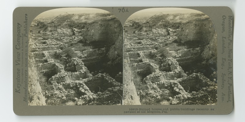 Still image
 Still image
 Still image
 Still image
 Still image
 Still image
 Still image
 Still image
 Still image