Search
4 resources
4 items
Publisher
Petri, Heinrich, 1508-1579
-
 Still image
Das erst general - inhaltend die beschzeibung [und] den [circtel] des gantzen erdtreichs und m[o]rcs.
A map of the world including latitude and longitude markers. Personifications of the winds are depicted withing croulds surrounding the map and various monstrous creatures are depicted within the oceans.A map of the world including latitude and longitude markers. Personifications of the winds are depicted withing croulds surrounding the map and various monstrous creatures are depicted within the oceans. -
 Still image
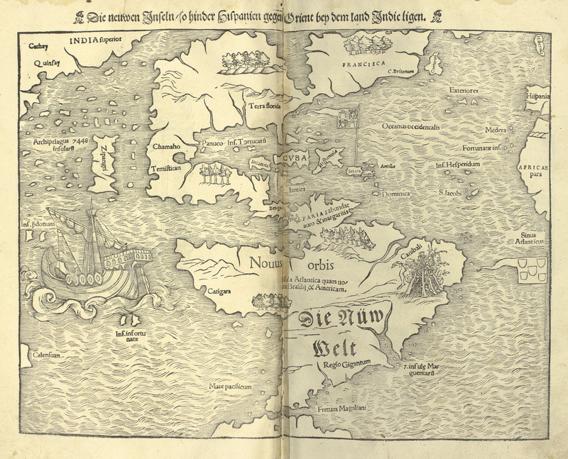
Die neuwen Inseln - so hinder Hispanien gegen Orient bey dem land Indic ligen.
A map of the western hemisphere, identified as the New World, and the western coast of Asia. A spanish style galleon ship is depicted sailing in the Pacific ocean, and a rough shelter built of sticks featureing a dismembered leg is depicted in the general region of Brazil with the label, "Canibali".A map of the western hemisphere, identified as the New World, and the western coast of Asia. A spanish style galleon ship is depicted sailing in the Pacific ocean, and a rough shelter built of sticks featureing a dismembered leg is depicted in the general region of Brazil with the label, "Canibali". -
 Still image
Gespängst der bösen geist
A woodcut depicting a hairy, bipedal beast, labeled as the "spook of the evil ghost," which is found in a vast desert beyond India in the land of Cathay. This type of ghost is said to lead travellers astray by mimicking the voices of their travelling companions.A woodcut depicting a hairy, bipedal beast, labeled as the "spook of the evil ghost," which is found in a vast desert beyond India in the land of Cathay. This type of ghost is said to lead travellers astray by mimicking the voices of their travelling companions. -
 Still image
Ptolemaisch general [catel] - [...] greiffend die halbe fugel der weldt.
A map of the world with latitude and longitude markers as it was known during the Ptolemaic period, including mountain ranges and rivers and spanning from Europe, to central Africa, and over to India. Personifications of the winds are depicted within the clouds surrounding the map.A map of the world with latitude and longitude markers as it was known during the Ptolemaic period, including mountain ranges and rivers and spanning from Europe, to central Africa, and over to India. Personifications of the winds are depicted within the clouds surrounding the map.