Search
9 resources
9 items
Subject
Early works to 1800
-
 Still image
Belvedere Gardens
Brambilla, Ambrogio, active approximately 1579-1599This view of the Belvedere Gardens and Courtyard at the Vatican is particularly important since it shows the courtyard as it was originally designed by Donato Bramante in 1505. Bramante's design offered an unobstructed prospect from the papal apartments (at left) through the length of the courtyard to the exedra, the semi-circular structure at the right of the image. This perspectival view was later blocked by the construction of a library for Pope Sixtus V in 1587-89.This view of the Belvedere Gardens and Courtyard at the Vatican is particularly important since it shows the courtyard as it was originally designed by Donato Bramante in 1505. Bramante's design offered an unobstructed prospect from the papal apartments (at left) through the length of the courtyard to the exedra, the semi-circular structure at the right of the image. This perspectival view was later blocked by the construction of a library for Pope Sixtus V in 1587-89. -
 Still image
Das erst general - inhaltend die beschzeibung [und] den [circtel] des gantzen erdtreichs und m[o]rcs.
A map of the world including latitude and longitude markers. Personifications of the winds are depicted withing croulds surrounding the map and various monstrous creatures are depicted within the oceans.A map of the world including latitude and longitude markers. Personifications of the winds are depicted withing croulds surrounding the map and various monstrous creatures are depicted within the oceans. -
 Still image
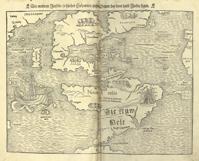
Die neuwen Inseln - so hinder Hispanien gegen Orient bey dem land Indic ligen.
A map of the western hemisphere, identified as the New World, and the western coast of Asia. A spanish style galleon ship is depicted sailing in the Pacific ocean, and a rough shelter built of sticks featureing a dismembered leg is depicted in the general region of Brazil with the label, "Canibali".A map of the western hemisphere, identified as the New World, and the western coast of Asia. A spanish style galleon ship is depicted sailing in the Pacific ocean, and a rough shelter built of sticks featureing a dismembered leg is depicted in the general region of Brazil with the label, "Canibali". -
 Text
TextFranc. Baconis de Verulamio, summi Angliæ cancelsarij, Novum organum scientiarum
Bacon, Francis, 1561-1626A work on the process of reduction and inductive reasoning, the precursor of the scientific method.A work on the process of reduction and inductive reasoning, the precursor of the scientific method. -
 Text
TextMœurs des sauvages ameriquains, comparées aux mœurs des premiers temps
Lafitau, Joseph-François, 1681-1746A description of the customs of indigenous peoples of the Americas as recorded by colonizing forces.A description of the customs of indigenous peoples of the Americas as recorded by colonizing forces. -
 Still image
Plan and Elevation of the Belvedere Garden of the Vatican Palace
Falda, Giovanni Battista, approximately 1640-1678The lower third of Falda's plan shows the Belvedere Court designed in 1505 by Donato Bramante for Pope Julius II (1503-1513) to link the palace with a fifteenth-century villa on the grounds. The small courtyard (no. 9 on the plan) at the lower right housed the incomparable collection of ancient sculpture begun by Pope Julius which included such works as the Laocoon.The lower third of Falda's plan shows the Belvedere Court designed in 1505 by Donato Bramante for Pope Julius II (1503-1513) to link the palace with a fifteenth-century villa on the grounds. The small courtyard (no. 9 on the plan) at the lower right housed the incomparable collection of ancient sculpture begun by Pope Julius which included such works as the Laocoon. -
 Still image
Ptolemaisch general [catel] - [...] greiffend die halbe fugel der weldt.
A map of the world with latitude and longitude markers as it was known during the Ptolemaic period, including mountain ranges and rivers and spanning from Europe, to central Africa, and over to India. Personifications of the winds are depicted within the clouds surrounding the map.A map of the world with latitude and longitude markers as it was known during the Ptolemaic period, including mountain ranges and rivers and spanning from Europe, to central Africa, and over to India. Personifications of the winds are depicted within the clouds surrounding the map. -
 Still image
Recentis Romae ichnographia et hypsographia sive planta et facies ad magnificentiam qva svb Alexandro VII P.M. vrbs ipsa directa excvlta et decorata est
Falda, Giovanni Battista, approximately 1640-1678Summary: A map of Rome including illustrations of historic buildings and churches of the city; and also includes names and insignia of the 14 regions of the city of Rome.Summary: A map of Rome including illustrations of historic buildings and churches of the city; and also includes names and insignia of the 14 regions of the city of Rome. -
 Text
TextSome memoirs of the life of Job the son of Solomon the high priest of Boonda in Africa, who was a slave about two years in Maryland, and afterwards being brought to England, was set free and sent to his native land in the year 1734
Bluett, ThomasSummary: The memoirs of Job, a man sold into slavery in Maryland and later England.Summary: The memoirs of Job, a man sold into slavery in Maryland and later England.