Search
19 resources
19 items
Subject
Maps
-
 Still image
Das erst general - inhaltend die beschzeibung [und] den [circtel] des gantzen erdtreichs und m[o]rcs.
A map of the world including latitude and longitude markers. Personifications of the winds are depicted withing croulds surrounding the map and various monstrous creatures are depicted within the oceans.A map of the world including latitude and longitude markers. Personifications of the winds are depicted withing croulds surrounding the map and various monstrous creatures are depicted within the oceans. -
 Still image
Die eigentliche warhafftige gestalt der Erden und des [...]
A map of the world including Europe, Africa ("Der schwarzen Moren Land"), Asia (Major), America ("Die Newe Welt"), and India Meridionalis (a so called "phantom" peninsula that was often depicted in Medieval and Rennaissance maps). A number of monstrous sea creatures are depicted in the various oceans and seas.A map of the world including Europe, Africa ("Der schwarzen Moren Land"), Asia (Major), America ("Die Newe Welt"), and India Meridionalis (a so called "phantom" peninsula that was often depicted in Medieval and Rennaissance maps). A number of monstrous sea creatures are depicted in the various oceans and seas. -
 Still image
Die ganze Welt in einem [K]leberblat Welches [...] meines lieben Vaterlandes [W]apen
A map of the world including Europe, Africa, and Asia as three leaf or petal shaped continents with America ("Die Newe Welt") draw in the bottom left corner. A ship and numerous sea creatures are depicted in the oceans.A map of the world including Europe, Africa, and Asia as three leaf or petal shaped continents with America ("Die Newe Welt") draw in the bottom left corner. A ship and numerous sea creatures are depicted in the oceans. -
 Still image
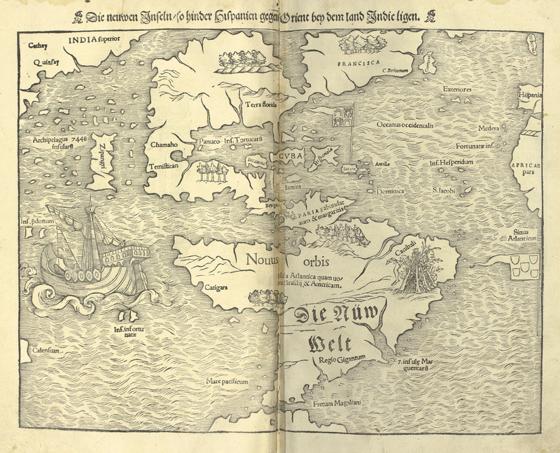
Die neuwen Inseln - so hinder Hispanien gegen Orient bey dem land Indic ligen.
A map of the western hemisphere, identified as the New World, and the western coast of Asia. A spanish style galleon ship is depicted sailing in the Pacific ocean, and a rough shelter built of sticks featureing a dismembered leg is depicted in the general region of Brazil with the label, "Canibali".A map of the western hemisphere, identified as the New World, and the western coast of Asia. A spanish style galleon ship is depicted sailing in the Pacific ocean, and a rough shelter built of sticks featureing a dismembered leg is depicted in the general region of Brazil with the label, "Canibali". -
 Still image
Disegno et sito del Sontovoso Giardino et Palazzo del Ser.mo Gran Duva di Toscana in Roma
Raphael, 1483-1520An engraving depicting the Villa Medici and gardens in Rome.An engraving depicting the Villa Medici and gardens in Rome. -
 Text
TextExplainations of Map System
A document explaining how to read various symbols and markings on the maps which accompany the steroscopic views of Palestine.A document explaining how to read various symbols and markings on the maps which accompany the steroscopic views of Palestine. -
 Still image
Giardino de gl'Ill.mi Sig.ri Mattei
Raphael, 1483-1520An engraving depicting the Villa Mattei, now known as Villa Celimontana, in Rome and the gardens surrounding.An engraving depicting the Villa Mattei, now known as Villa Celimontana, in Rome and the gardens surrounding. -
 Still image
Giardino del Emi.mo Card. Montalto
Raphael, 1483-1520An engraving depicting the gardens and palace of Villa Montalto (also known as Villa Montalto Peretti, Villa Montalto Peretti Massimo, and Villa Negroni) in Rome. The entire complex was leveled to make room for the Roma Termini.An engraving depicting the gardens and palace of Villa Montalto (also known as Villa Montalto Peretti, Villa Montalto Peretti Massimo, and Villa Negroni) in Rome. The entire complex was leveled to make room for the Roma Termini. -
 Still image
Giardino di Belvedere col Palazzo del Papa in Vaticano
Raphael, 1483-1520An engraving of the Belvedere Gardens in Vatican City, as well as the Vatican Palace and Belvedere Court.An engraving of the Belvedere Gardens in Vatican City, as well as the Vatican Palace and Belvedere Court. -
![Map of Jerusalem taken from Sebastian Münster's Cosmographia (Basel: Heinrich Petri, 1544), YY4-5 (pages [1015]-1018).](https://s3.us-west-2.amazonaws.com/omekacloud-main/large/P_MSS400_B001_F003_I001/P_MSS400_B001_F003_I001_P001_PROD.jpg) Still image
Still imageIerusalem ciuitas sancta, olim metropolis regni Iudaici, hodie uero colonia Turcae
Map of Jerusalem taken from Sebastian Münster's Cosmographia (Basel: Heinrich Petri, 1544), YY4-5 (pages [1015]-1018).Map of Jerusalem taken from Sebastian Münster's Cosmographia (Basel: Heinrich Petri, 1544), YY4-5 (pages [1015]-1018). -
 Still image
Il Palazzo Papale
Raphael, 1483-1520An engraving depicting the Papal Palace (also known as the Vatican Palace, Apostolic Palace, and Palace of Sixtus V) and gardens located within the Vatican City in Rome.An engraving depicting the Papal Palace (also known as the Vatican Palace, Apostolic Palace, and Palace of Sixtus V) and gardens located within the Vatican City in Rome. -
 Text
TextLois Augusta Robinson to Donald and Elsie Lerch, September 16, 1956
Robinson, Lois AugustaA letter from Lois to her parents, Donald and Elsie, asking them to renew her and Morrell's US driver's licenses, mentioning that Morrell is working to get his Cuban driver's license, sharing a photograph of Steed and asking for them to make copies to share with other relatives, asking for a few more things to be brought with them when they visit (dish cloths, pajamas for Steed, a pair of shoes, Morrell's golf clubs), expressing happiness and anticipation of their visit, describing a map of Holguin which Morrell drew (and was included with the letter at the time of sending)A letter from Lois to her parents, Donald and Elsie, asking them to renew her and Morrell's US driver's licenses, mentioning that Morrell is working to get his Cuban driver's license, sharing a photograph of Steed and asking for them to make copies to share with other relatives, asking for a few more things to be brought with them when they visit (dish cloths, pajamas for Steed, a pair of shoes, Morrell's golf clubs), expressing happiness and anticipation of their visit, describing a map of Holguin which Morrell drew (and was included with the letter at the time of sending) -
 Text
TextMorrell Steed Robinson to Elsie Lerch, April 20, 1956
Robinson, Morrell SteedA letter from Morrell to Lois' mother, Elsie, thanking her for her letter and her kindness to him, expressing his and Lois' appreciation for the Milks (another missionary couple), giving an update on Lois' health, describing Lois' new haircut, sharing a story about his pants being stolen, expressing his sadness over the state of steak, and providing a map of the neighborhood where they live.A letter from Morrell to Lois' mother, Elsie, thanking her for her letter and her kindness to him, expressing his and Lois' appreciation for the Milks (another missionary couple), giving an update on Lois' health, describing Lois' new haircut, sharing a story about his pants being stolen, expressing his sadness over the state of steak, and providing a map of the neighborhood where they live. -
 Text
TextMorrell Steed Robinson to Elsie Lerch, August 16, 1956
Robinson, Morrell SteedA letter from Morrell to Lois' mother, Elsie, apologizing for not visiting of calling while he was in Florida, describing his trip to Jacksonville and then Fort Lauderdale, listing the things he had brought back from Florida (gifts, a tape recorder, etc.), reporting on his family's health and well being, describing his work with the Bible Schools and camp sessions, giving an update on Lois' health and her pregnancy, sharing his plans for taking Lois and Steed to the beach, expressing satisfaction and enjoyment in his work and ability to speak in Spanish, asking if a letter heA letter from Morrell to Lois' mother, Elsie, apologizing for not visiting of calling while he was in Florida, describing his trip to Jacksonville and then Fort Lauderdale, listing the things he had brought back from Florida (gifts, a tape recorder, etc.), reporting on his family's health and well being, describing his work with the Bible Schools and camp sessions, giving an update on Lois' health and her pregnancy, sharing his plans for taking Lois and Steed to the beach, expressing satisfaction and enjoyment in his work and ability to speak in Spanish, asking if a letter he -
 Still image
Pitratto nel quale si rappresenta il vero sito dell'Horti et Fontane che coningeniosissimi adornamenti et maraviglie si vedono nella Villa in Tivoli, fata dalla fe me di Hippolito da este Card. di Ferrara
Raphael, 1483-1520An engraving of the gardens and palace of the Villa d'Este in Tivoli outisde of Rome.An engraving of the gardens and palace of the Villa d'Este in Tivoli outisde of Rome. -
 Still image
Ptolemaisch general [catel] - [...] greiffend die halbe fugel der weldt.
A map of the world with latitude and longitude markers as it was known during the Ptolemaic period, including mountain ranges and rivers and spanning from Europe, to central Africa, and over to India. Personifications of the winds are depicted within the clouds surrounding the map.A map of the world with latitude and longitude markers as it was known during the Ptolemaic period, including mountain ranges and rivers and spanning from Europe, to central Africa, and over to India. Personifications of the winds are depicted within the clouds surrounding the map. -
 Still image
Relief map of Palestine by the Palestine Ex. Soc.—vertical scale 3 1/2 times greater than horizontal
Hurlbut, Jesse Lyman, 1843-1930View of a relief map prepared by the Palestine Exploration Society depicting the topography of Palestine and identifying various notable locations.View of a relief map prepared by the Palestine Exploration Society depicting the topography of Palestine and identifying various notable locations. -
 Still image
Villa Borghesia
Raphael, 1483-1520An engraving depicting the Villa Borghesia and its surrounding gardgensAn engraving depicting the Villa Borghesia and its surrounding gardgens -
 Still image
Villa de l'Ecc.mo S.re Principe Panfilio fuora de la Porta di S. Pancratio
Raphael, 1483-1520An engraving depicting the gardens and villa of the Pamphilli family, located near the Porta San Pancrazio in Rome.An engraving depicting the gardens and villa of the Pamphilli family, located near the Porta San Pancrazio in Rome.